https://www.bbc.co.uk/news/magazine-16657363
"...several larger pits were recorded in areas suggested by witnesses as the locations of mass graves and cremation sites.
One is 26m long, 17m wide and at least four metres deep, with a ramp at the west end and a vertical edge to the east.
Another five pits of varying sizes and also at least this deep are located nearby."
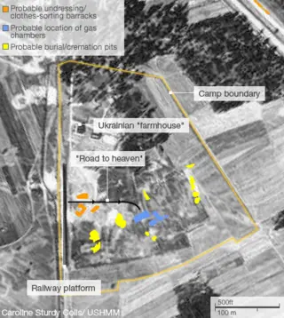
They are the pits around the main memorial, which is to the right of the blue area on the map below;
 https://etheses.bham.ac.uk/id/eprint/35 ... s12PhD.pdf
That is the area of the camp multiple witnesses identify as being the location of the main mass graves. In 1945, a Polish site survey identified an area of 2 hectares, where there was disturbed ground containing human remains, which witnesses identified as being the area where the main mass graves were located. The Poles conducted a series of excavations, confirming buried human cremated remains, one of which got 7m deep, before undisturbed ground was found. That is the area in which the mass graves were located, but the Poles could not be specific about where the actual graves were in that area.
Geophysics has been able to be more specific about which parts of that area are disturbed and which are not. The disturbed parts are shown in yellow, around the main memorial. on the above map and in the linked to report, they are described as;
"...to the west of the memorial in this area a further feature was identified
that was also bisected by the concrete (G36). This feature was shown to be
rectilinear in plan within the GPR results and is located in the area believed to have
contained graves..."
It is recorded as 9m by 6m, and it may be a structure, according to appendix 4.3.6.
"Five pits were located with the GPR (G50-G54) on the eastern side of the Death
Camp (Figures 4.29 and 4.34). Although the GPR survey was unable to achieve a large
enough depth range to determine the full extent of these pits, it is possible to say
that they were all deeper than four metres and that they were all of considerable
size in plan (G50 was visible to an extent of 34m x 12m, G51-19m x 12m, G52 – 22m
x c.15m, G53 – c.18m x 7m and G54 was visible to 20.8m x c. 14m). Given their
location in the area thought to contain most of the mass graves and their proximity
to the memorial, there is a strong case for arguing that they represent further
disposals. Similarly, they appear too large to be a result of post-war looting activity."
The total area is (9x6)+(34x12)+(19x12)+(22x15)+(18x7)+(20.8x14)= 1437.2m2. The survey depth was 4m and in many cases the disturbed ground exceeded that, but if we take 4m as an average depth, that is a total volume of 1437.2x4= 5748.8m3.
If we use the 7m depth found by the Poles, then that total volume is 1437.2x7= 10,060.4m3. In another thread I estimated roughly 3.5 Olympic sized swimming pools, which is 8,750m3. The survey was also only of what was visible to GPR, as they could not survey under the memorial.
We could quibble all day long about how much undisturbed ground there is, but geophysics proves at least 5748.8m3, or the equivalent to 2.3 Olympic sized swimming pools, in the area identified by witnesses as the location of the main mass graves and where the Poles identified the main area of disturbed ground in the camp.
So-called revisionists will deny that is evidence of the mass graves, but if they are revisionists, they will provide evidence to revise why the Nazis dug so much of the camp up and what is buried in those pits. Of course, we know they cannot. Which means mass graves is the only evidenced option.